Morning in
Chitina came at a more civilized hour today. Plus, our room was darker last
night as a result of being in a steep canyon with overcast skies, and that
helped with our sleep. After breakfast, we loaded our gear into the car for the
60 mile drive to McCarthy.

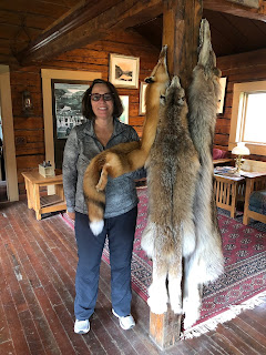
Before
leaving town, we stopped at the ranger station. It’s housed in a 1910 log cabin
that was originally built and used by the owner of the stagecoach company that
served the area. We picked up a map and a complimentary audio CD. And, Karen
made her by-now-obligatory visit with the animal pelt display. It was raining
lightly as we hit the road.
The McCarthy
road is partly ‘paved’ and partly gravel. For the most part, it follows the old
Copper River and Northwestern Railway grade all the way to McCarthy. The CRNR
was built back in 1908 to bring copper from the Kennicott mine down to Prince
William Sound. This stretch of road is why we paid extra for a car rental – the
periodic road grading maintenance still churns up old railroad spikes and other
debris that keep the local tire repair guys in business (the repairman in
Chitina is aptly named Daniel Boone). Our car came with two spare tires, a CB
radio for emergency use, and permission from the rental company to take it off-highway.
Within the
first mile or two we got our first look at the Copper River. This particular
spot is apparently a favorite one for locals. Half the population of Chitina
are Ahtna, and they have rights to personal and subsistence fishing. Looking
down at the river, we could see fishwheels and dip nets being used to catch
Copper River red sockeye salmon.

After
following the river for several miles, we came to large meadows with lots of
ponds. Many of them had flowering lily pads in them.

To cross the
Kuskalna River, we used the old single-lane (track) railway bridge that is more
than 200 feet above the river. I walked out onto the bridge to snap some photos
and encountered my old friend, acrophobia. Our audio guide told us this bridge
didn’t even have guardrails until relatively recently!


At the
Gilahina River, we took time for Karen to smell the flowers (see my note at
bottom)*. We also walked under the ruins of the 890 foot long wooden rail
trestle. Today, with its off-kilter supports, it looks like something out of an
Indiana Jones film.


With rain
still coming down, we came to the end of McCarthy road. We loaded our gear into
a van for a short ride to the raging Kennicott River. We carried our stuff over
the river on a small pedestrian bridge, and caught a shuttle van to our lodge
five miles further up the canyon.
Kennicott was
quite the copper mining town back in the day. Now, it’s a haven for tourists,
backpackers, and ice climbers. We’re in the first category, so we had a nice
salmon dinner at the lodge. One of our tablemates tonight is a vacationing
neo-natal nurse who works in Anchorage. She provides care for native Alaskan
women who need to be flown in from remote villages for childbirth and other related
health needs. She said it’s a challenging, yet fulfilling job.


We’ve signed
up for a glacier hike tomorrow. The skies have cleared up a bit this evening
and the weather forecast for tomorrow is…who knows? According to our guides, we
go out no matter what. So, it’s early to bed tonight.
Next: Hike on
Root Glacier
*(notes on
Day 10 update: I was misinformed on the identity of the forget-me-not flower –
the pictures I put up are actually alpine primrose; also, we were at North Pole
on Monday, not Tuesday.)
Bluebells
 Kennicott Miner's Lampshade 'wildflower'
Bluebells


No comments:
Post a Comment