Just a mile from our Port Ludlow lodge is the trailhead to Ludlow Falls. This easy path comes in just under a mile long and winds through some lovely stands of cedar, elm, and maple trees, many of which are covered in licorice ferns. Old logging railroad detritus can also be found along the trail. The falls is really a cascade, but it is very photogenic. Our pre-breakfast hike on this trail got us ready to hit the road.
Since we were going northward, we had to stop again at the Spruce Goose Cafe to have another airfield diner breakfast. Then, it was off to Port Angeles.
Highway 101 is the road that encircles Olympic National Park. Today’s trip took us along the northern section of the Olympic Peninsula through towns like Discovery Bay, Gardiner and Sequim. This area seems pretty heavily populated and the road had its share of retail shopping centers and small housing subdivisions.
Once we got to Port Angeles we turned south for a few miles until we came to the Olympic National Park Visitor Center. After a quick discussion with the park ranger, we continued south up into the mountains on a 17 mile drive along the Klahhane Ridge toward the Hurricane Ridge Visitor Center.
At the beginning of our drive we were very close to sea level. The temperature was in the high 40’s F. and the sky was cloudy. As we climbed in elevation we quickly entered a thick and drizzly cloud bank that kept us in very low visibility conditions for most of the remainder of our drive up the mountain.
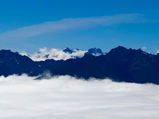
Within the last quarter mile of the drive, we broke through the clouds into bright sunshine and clear blue skies. To the southwest, we could see Mount Olympus and Blue Glacier, along with several other peaks in the Olympic Range. To the north we could see into Canada and Vancouver Island. The surrounding mountains seemed to be floating on a thick layer of white clouds below us.
At just over 5200 feet of elevation, Hurricane Ridge is one of only two areas in the U.S. where there is a ski area within a national park (the other is Badger Pass in Yosemite, where I’ve skied in the past), and you can see the ski lift equipment at the top of the ridge (although the lift looks like it hasn’t operated in a couple of years). We took a little hike, snapped some photos, and received a message from ATT that our International plan was available, thinking we were in Canada. We then jumped back into the car to go back down the mountain to see Lake Crescent and Marymere Falls, which are to the west of Port Angeles.
The short hike to Marymere Falls takes you through a thick forest of ferns, hardwoods and conifers with lots of hanging moss and strange fungal growths on fallen logs. Some of these trees are huge. And one tree even gave me a strange Winnie The Pooh experience.
The waterfall is a ribbon-type fall that is about 90 feet tall. A series of slippery switch-backs and stairs takes you up to a good vantage point for viewing.
By this time, it was starting to get dark and we drove over to the Lake Crescent Lodge to check in for the night. It seems everyone else in the area had the same idea, because there was a large crowd of people waiting ahead of us. After a short wait, we got situated in our room. The lodge (built in 1916) is right on the edge of Lake Crescent, which is a 12 mile long lake created long ago by glaciation. The view from shore is quite nice.
We didn’t have dinner reservations at the lodge, and the restaurant was completely booked up for the evening. However, we were able to order from a limited take-out menu at the bar and we ate in our room.
There’s no wi-fi in the rooms, and the cell service is virtually non-existent, so we’re heading over to the main lobby later (where there is wi-fi) and try to upload today’s post.
NEXT: Rainforests and Lake Quinault


No comments:
Post a Comment