Monday, October 18, 2021

Days 17 & 18 - Seeing the “Northern Wright’s”, Whidbey Wanderlust, Cowabunga on the Coast, Deceptive Trail - October 17 & 18, 2021

 Sunday morning on Lopez Island was cool and misty as we waited for the ferry to Anacortes. Karen took in some fresh air on the ‘pickle fork’ deck on the ride over. A few dolphins cavorted in the boat’s wake along the way.


It was time for Uncle Steve and Aunt Karen to pay a visit to their nephew, Adam, his wife Amy and their two sons, Finnegan and Forrest. It has been more than four years since the last time we’ve seen them.


Adam and Amy have really settled into the Pacific Northwest lifestyle. They’re wearing T-shirts, while we’re bundled up in coats and jackets. They mix their full time careers with hiking, running (Amy just participated in a half marathon last week, and Adam’s training for a 50K ultra marathon in a couple weeks), soccer (Finnegan) and gymastics (Forrest), among other activities.


After getting brought up to date on the ‘Wings of Fire’ graphic novel series, we headed out for a nice dinner in downtown Snohomish and a quick walk along the riverfront. By the time we finished, it was time for us to get to our hotel for the evening. Although it was a short visit, we had a wonderful time and we hope to see these guys again soon.


This morning (Monday) was a picture perfect autumn day - crisp, cool and clear with no wind. We caught the ferry from Mukilteo to Whidbey Island with no problem, and we were on our way.


First stop was the artsy little village of Langley on the southeast end of the island. There’s a whale museum in town that keeps track of daily whale sightings in the Saratoga Passage between Camano Island and Whidbey Island. Like in many fishing tales, we should have been there yesterday - that’s when a couple of humpback whales were spotted. Today, no luck…


From there, we got on the main drag, Highway 525, and went north to the community of Greenbank, where there were supposed to be some seaside bluff views of Holmes Harbor. We didn’t see them, but we found Hidden Beach on a little side road.


It was time for another lighthouse, so we went over to the west side of the island to Fort Casey State Park. In contrast to the gigantic artillery gun emplacements left over from the early 20th century, there were gentle little deer grazing in the nearby grassy fields.


While there, we saw a woman going through the fields filling a large bag with wild mushrooms. Karen asked her how she knew these were safe to eat. She told Karen that she was a researcher and this was the perfect time to harvest, dry, and eat these ‘meadow’ mushrooms. To me, they just looked like the toadstools you see in your front yard - no thanks!


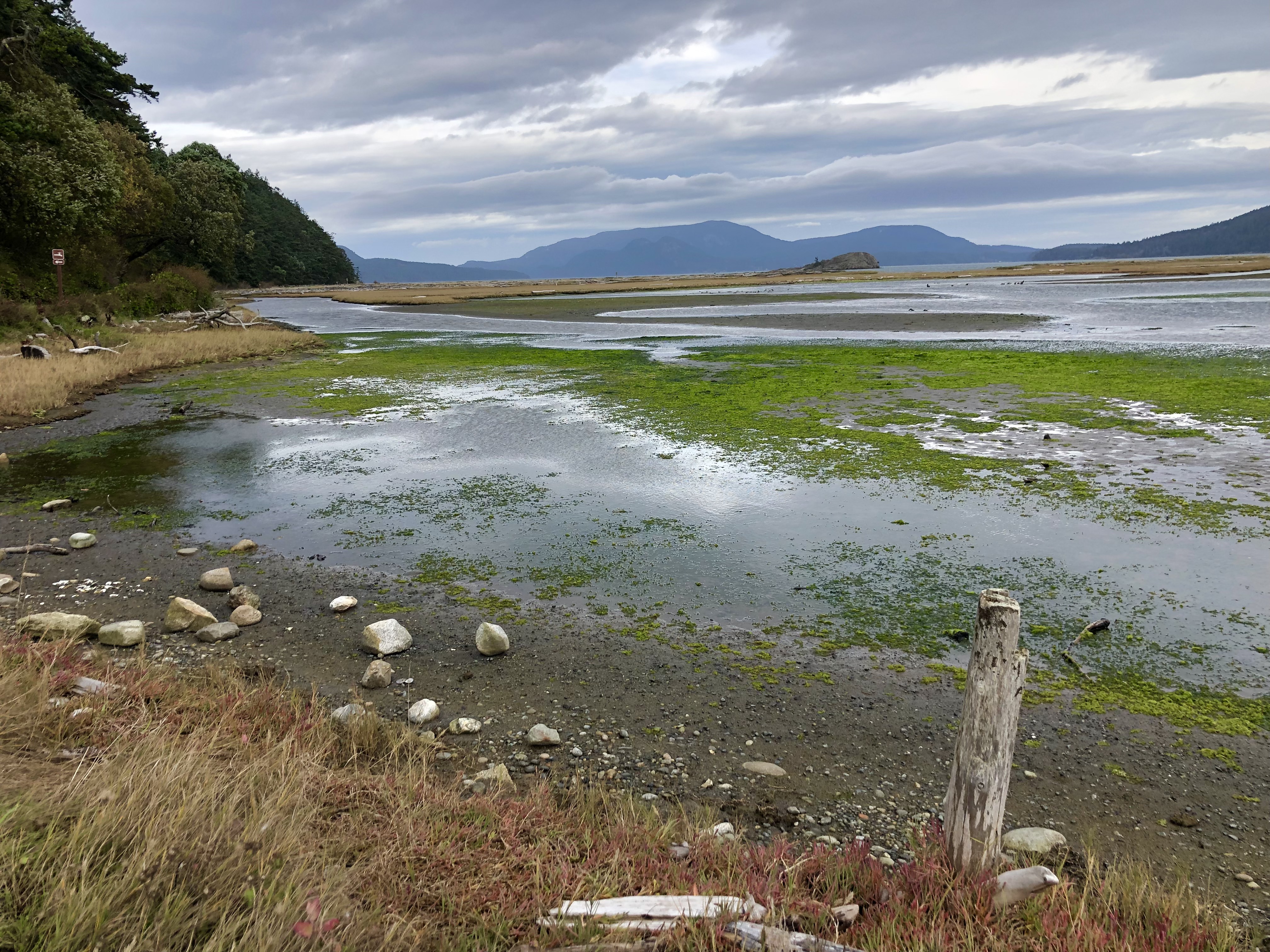
Next, we made a short stop at Ebey Landing Overlook. This looks down on a fertile farmland valley on the central west coast of the island. There is also a cemetery on this road that has a so-called ‘blockhouse’ on it. This one, the Davis Blockhouse, was built in 1855 as defense against the indigenous tribe on the island. It seems there was an attack against the settlers in retribution for some U.S. ‘relocation’ skullduggery the year before that had resulted in the loss of several tribal members.


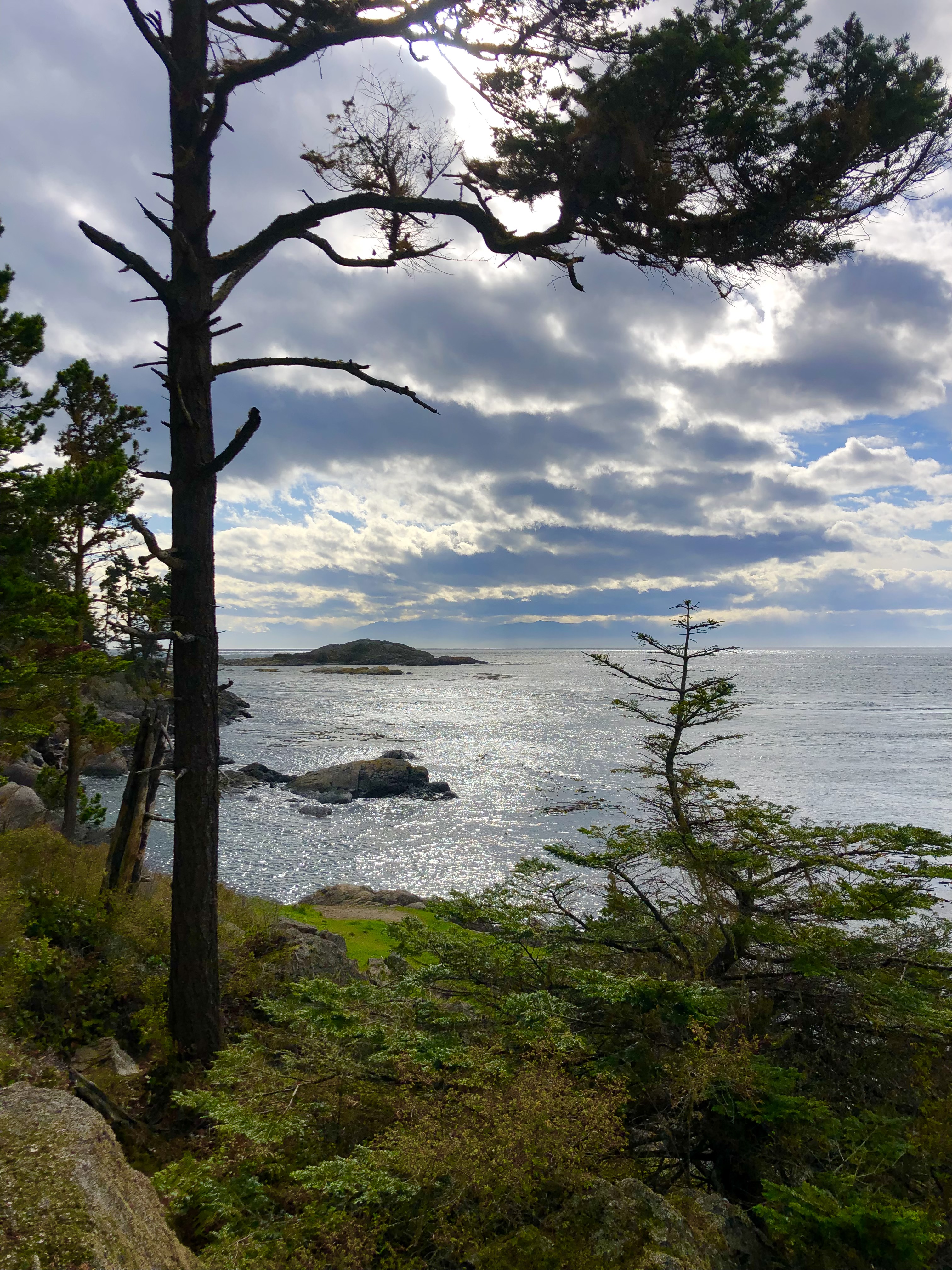
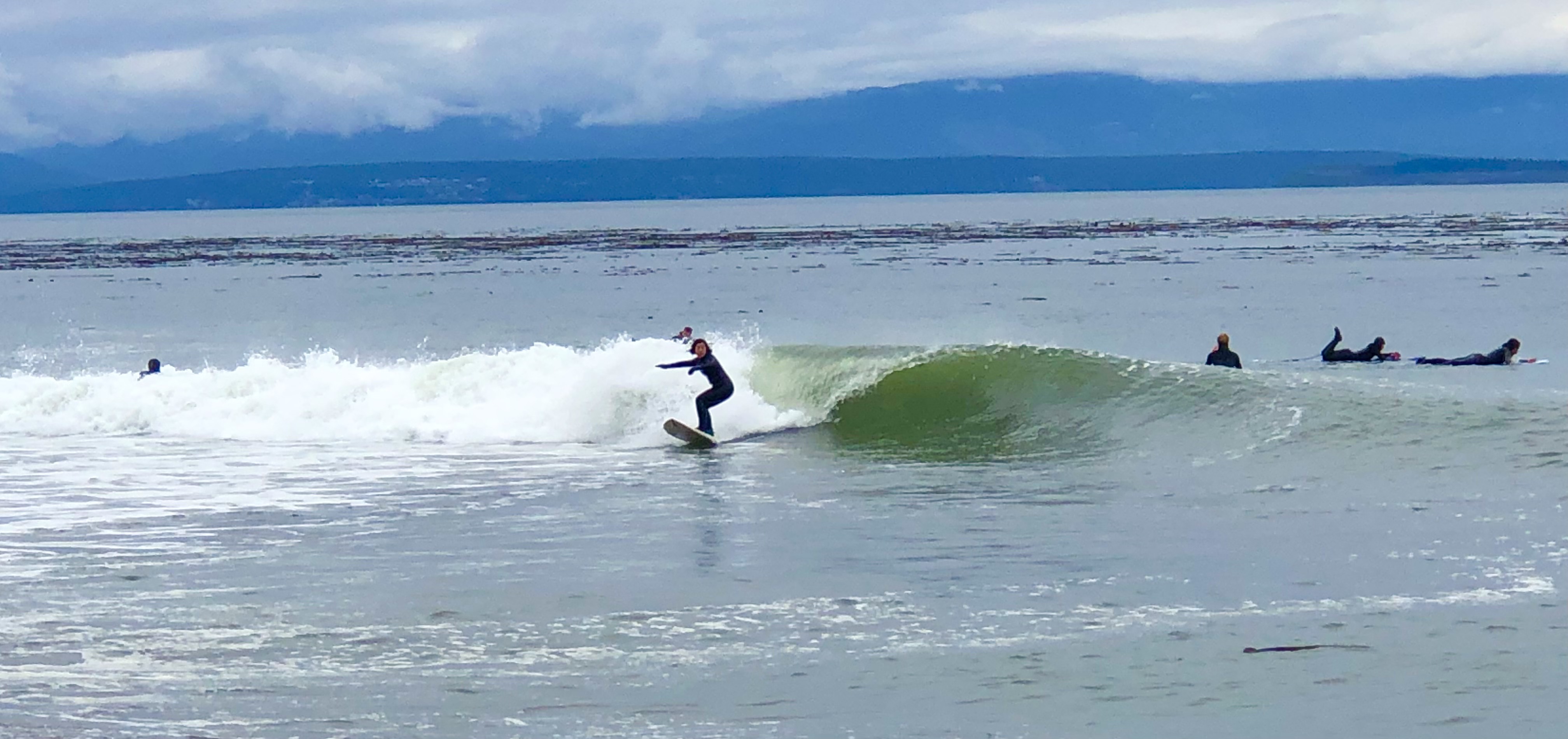
Further up the west coast is Fort Ebey State Park. When we got there, the sun had gone away and it was cold and overcast. We’ve noticed that the trees on all these islands tend to capture whatever moisture is in the air and keep it localized in the forested areas. The roads and trails always seem to be wet and cold. This is perfect weather for - surfing! With the cloud covered Olympic Range across Admiralty Inlet as a background, these guys were pumping the shore break like they do down in Huntington Beach.


At the north end of Whidbey Island is Deception Pass, named by the explorer, George Vancouver, because he was so disappointed in the navigability of this narrow channel between Whidbey and Fidalgo Islands. George was charitable enough, however, to name Whidbey Island after his junior officer, Joseph Whidbey (who was the one who sailed into Deception Pass and had the unenviable task of telling his boss it wasn’t a good route).


There’s an impressive bridge across the pass, and you can see it from the day use area of the State Park. A hiking trail goes from the park to the bridge on a 2 mile round trip route.  I set my Strava to ‘hike’ mode and took off on the trail to get some photos. About a quarter mile later, I had a George Vancouver moment when I realized the trail was closed. No one had told me about this. There was no indication of this until I came upon it. I felt…deceived!


Back on the road, we found a pull out just before crossing the bridge. It was all I could do to hold my hands steady on the camera as I looked over the edge into the churning eddies of current down below. There’s lots of construction going on right now in the vicinity of the bridge, and a whole team of painters was working on the structure as traffic flowed by.


On the way back to Everett, we stopped at the waterfront town of La Conner. It’s set in flat farmland near Skagit Bay and looks like it’s probably a hopping little place on the weekends. Today was pretty quiet.


Last stop tonight was the Scuttlebutt Brewery right across the parking lot from our hotel. Karen had a pineapple upside down cake cocktail made with locally-distilled brown sugar bourbon. It tasted just like you were biting into a freshly baked cake. Back in the room we’re figuring out how to get all our stuff back into the suitcases, after having half our stuff strewn about the rental car for the past three weeks.


NEXT: Back Home

Saturday, October 16, 2021

DAY 16 - Spit In The Wind, Stroll In The Sun, No Bikes Today - October 16, 2021

 With a stiff 20 mph wind blowing this morning, we decided not to ride bikes. Instead, we drove up to the northeast corner of Lopez Island to see Spencer Spit State Park.

As the road drops down toward the beach, you can see a long stretch of sand and gravel going out eastward from the shore. At the end of this spit is a narrow channel with a big rocky island (Frost Island) just beyond it. The water between the spit and the island is like a rushing river flowing from south to north. The strong winds from the south today were making the current even stronger, and they were also making it difficult to walk in a straight line along the exposed shoreline.


Next, we drove over to the northwest side of the island to visit Upright Channel Park. A feature of most of these beach access trails is a steep drop down to the beach from the trailhead. This means a steep walk back. Karen decided two hikes today were enough for her.


As the sun began to come out, we drove over to the Shark Reef Park trailhead and Karen let me take a quick walk out to see the view. The trail starts through a boggy section of forest before it gets to the edge. From the cliffside trail, you can then look west and see Friday Harbor (San Juan Island) and the Cattle Point Lighthouse just across the channel. The ocean current here was also surging very strongly from south to north.


Later in the afternoon, Karen visited the local quilt studio while I took a little hike to Lopez Hill. The hill is located in the central part of the island and has a network of trails that wind up to the summit. There is no view from there because the hill is covered in a dense mossy forest.


Today is the start of hunting season for all types of firearms on the island, but I decided (like yesterday) not to wear the safety vest provided at the trailhead by the San Juan County trail volunteers. I didn’t see another person on the trail until the last 500 yards, when I saw a guy dressed in fatigues and a bright orange vest standing just ahead of me. He was carrying a very long 12 gauge shotgun over his shoulder as he peered into the forest along the trail. I asked him if he’d seen anything yet (they hunt for deer here), and he said he had not. I did some quick-stepping back to the car. As I drove away, I could see at least two other guys in bright hunter’s vests hunkered down in stalking positions in the bushes lining the road. I guess the first day of hunting season must be the best (but maybe not the best day for hiking) one.


Back at the inn, we ordered take out dinner from a local restaurant and played some Scrabble in the large front parlor room. We head back to the mainland tomorrow.


NEXT: Adventures in Everett

Friday, October 15, 2021

Days 14 and 15 - Waving, Wind, Wet Weather - October 14 & 15, 2021

 Our final night at Orcas was relaxing in our knotty-pine-panelled cabin as the rain fell steadily.


After another breakfast of pancakes, eggs and sausage cooked on the crazy stove, we packed up our stuff. Just as we were ready to leave, the camp repairman pulled up to our cabin in his cart with a brand-new electric stove on board. At least the next guests will have a more ‘balanced’ cooking experience.


The ferry loading area was pretty low-key at Orcas, and after a relatively short wait we were on our way to Lopez Island.


The first thing we noticed as we drove onto Lopez Island was that the drivers of every oncoming car we saw on the road would wave to us as we passed by. It was not a big obvious wave, just the raising of the fingers on the steering wheel hand in a casual acknowledgement. We don’t know how this custom got started, but it’s been consistent everywhere we’ve driven since we got here.


Our first stop on Thursday was Fisherman’s Bay Spit Preserve. Most of the land here is private, and the access to beaches is made possible by cooperation of private landowners and the County of San Juan. Small public easements allow trails into designated parks and preserves. The FB Spit is one of the few sand dune areas in any of the islands. It forms a protective barrier for the bay near the Village of Lopez. We had a picnic lunch and a short nature walk in between rain showers.


We checked into the Edenwild Inn later in the afternoon. It’s a vintage house in the village area and we have a cozy room with a fireplace. Edenwild boasts the ‘fastest wireless on the island’. That’s a good thing, since there’s virtually no cell service here.


It looks like we’re pushing the envelope as far as weather and the availability of tourist resources. As the season is winding down, there are not a lot of people around. Admittedly, Lopez Island is the most rural of the islands we’ve seen so far, but we found it to be pretty buttoned-up at this time of year. Many of the local business owners have chosen to take their own vacations now that summer has gone and the crab apples have laden the trees.


Friday morning saw us get off to a leisurely start after our in-room continental breakfast. With the wind blowing and the rain falling, we drove down to the south end of the island to visit Agate Beach and Iceberg Point.


The beaches here are made up of cobblestones and large (and some very large) pieces of driftwood logs. Apparently, there used to be agates at Agate Beach but all that remains now is the name. The permanent staircase down to the beach was washed away long ago, and the temporary metal stairs have been moved inland for the winter. I was able to slide down for a closer look and confirm there are now only cobblestones left for curious beachcombers.


The trail to Iceberg Point was definitely worth the drive. It is a hiking path that winds through various private properties in a thickly wooded forest until it comes out at the southern tip of the island. 


Along the trail, we came upon a sign warning us that it is hunting season. Local trail volunteers left a container of high visibility vests for hikers to wear if they want to. It seems we just missed the archery hunting season, as well as the muzzleloader hunting season. However, we were very near the ‘general’ hunting season. Since Karen was wearing a bright pink raincoat, I decided not to wear a vest as long as I could stay close to her on our walk.


Iceberg Point is a rocky and windswept promontory with some stunning views of Canada to the southeast and the Cascades of the Washington mainland to the southwest.


There is a reference marker (circa 1927) at this spot indicating it as ‘turning point 7 of the U.S. and Canada boundary between the 49th parallel and the Pacific Ocean’. I don’t know what this means in terms of cartography, but if you look at a map, the international border seems to wind its way along the Strait of Juan de Fuca and throughout the San Juan Islands and Canada. 


Our next stop was at Watmough Bay on the southeastern end of the island. After a short drive on an unpaved road, and then a short walk through a fern lined path, we came out to the small bay. The north edge of the bay is bordered by sheer rocky cliffs that rise several hundred feet right out of the water.


By this time, the rain and wind were beginning to increase, so we decided to stop by the local grocery store and get some food for dinner. We’ve been eating in restaurants for nearly three weeks, so this was a nice break from that. Tonight will be a quiet evening listening to the wind and rain outside. Tomorrow’s forecast is for less rain, but more wind. Maybe we’ll try some bicycling?


NEXT: Bicycle Ride

Wednesday, October 13, 2021

DAY 13 - Crazy Country Cooking, Cloudy Constitutional Climb (C.C.C.), Canine Consolation Chili - October 13, 2021

 We had pancakes, sausage and eggs for breakfast this morning. How we got there was not so easy. The little electric stove in our cabin seems to have a mind of its own. We learned today that only two of the four burners work. Also, the oven comes on even when the dial is turned to the ‘off’ position. In addition, the two functioning burners have somehow become tilted so that any pot or pan placed on them sits at a 25 degree angle.


In any event, the asymetrical pancakes were a tasty complement to the sausage and eggs. The camp repairman came over later to inspect the stove and offered to swap it out, until he learned from the electrician that our 40 amp stove circuit would not work well with the 50 amp replacement stove. His recommendation: switch off the breaker when the stove was not in use. So, that’s how we’ll roll with the stove for the remainder of our stay.


Out on the road, our first stop was Moran State Park, and the trailhead out to see Rustic Falls and Cascade Falls. As soon as you drop down onto the trail, you’re in a wet rainforest environment. With the temperature in the low 40’s, we were feeling the chill.


Next, we took the steep and winding road up to the top of Mt. Constitution. It is the highest peak in the San Juan Islands (it is also the second highest mountain on an ocean island in the lower 48 states - Devil’s Peak on Santa Cruz Island, Channel Islands National Park - is the highest. I can now say I’ve been to the top two island peaks in the U.S.)


At the peak is an observation tower built by the Civilian Conservation Corps (C.C.C.) in 1933. Its architect patterned it after a medieval tower. Unfortunately, we were right in the middle of rain clouds today and we had no view from the tower.


Luckily, when we got back down the road a couple of miles, we got a fantastic view to the south. We could see Friday Harbor off to the southwest, British Columbia to the west, and  Anacortes to the southeast.


We kept going south and stopped for a short hike in Obstruction Pass State Park, where there are lots of Pacific Madrone trees along the precipitous cliffs.


By the time we got back to camp, it was starting rain again so we tripped the breaker, turned on the stove, and had some bratwurst and chili for dinner.


We had plenty of leftover chili and Karen decided to put it to good use. She took some over to our next door neighbors, who gratefully accepted it. 


There is a small back-story to this chili offering:  When we first arrived last night, I was carrying our suitcases down the short road to our cabin. Suddenly, a couple of yappy little mongrels came charging toward me. I admit I was a little tired, and maybe not the most cheerful camper at that moment. I asked the dog owner if her animals always did that, and I pointed out that we’d be their neighbors and asked if her dogs would be barking like that all night. She seemed a little taken aback, but assured me her pups were well behaved.


Karen overheard this exchange and pointed out to me that I had been somewhat less than tactful in this situation. I agreed, but also argued that my preemptive comments probably set the stage for more canine control. I noticed the owners took extra care to keep those mutts quiet the rest of the evening.


The beach is quiet again tonight. 


NEXT: Ferry to Lopez Island