El
Capitan State Beach –
May 30 to June 2: After a couple of
weeks back from our big spring trip, we were brimming with confidence as we
headed out for our short trip up the coast to camp at El Capitan. We felt
pretty lucky to score three nights in a row at a popular beach campground right
after the holiday weekend. In the week preceding this trip, we’d picked up a
few trailer items we believed would make a big difference in the overall
balance and stability of our camping experience. The first thing was a pair of lightweight
stabilizer jacks for the front of the trailer. The second was a set of plastic
wheel chocks to replace the wooden 4 x 4’s we’d been using. The third was a set
of plastic leveling blocks to replace the wooden 1 x 4’s we’d been using. The
fourth was a small plastic folding foot stool that Karen could use to rest her
feet upon while we were traveling in the car, and to use while sitting around
the campground. The fifth thing was a membership in the Camping World/Good Sam
Club – looks like we’ll need those discounts.
One
of the ways you can really appreciate getting out of town is to go through the
experience of actually trying to get out of town. We thought leaving at around
noon on a Tuesday would give us a shot at moving through the urban jungle at a
reasonable pace. After nearly two hours, and only 63 miles, we finally made the
northwestern border of Los Angeles County. It was pretty clear sailing once we
got west of Camarillo. When you get a glimpse of the Pacific Ocean, you start
to feel like you’ve finally made it out into vacation land.

Our
campsite at El Capitan was set back among the oak and eucalyptus trees on the
bluff above the beach. We had a creek just behind us, along with a huge train
trestle towering above it. Each evening at around 6:00PM, a growing chorus of frogs began their nightly songs. This usually lasted until about 10:00PM.
Joining these soothing sounds of late spring were the occasional blasts of the
Amtrak Pacific Surfliner trains roaring through the tree canopy behind us. And,
when the breeze was blowing in from the southwest, you could hear the waves
crashing on the beach. On this stretch of the coast, the beaches face directly
south. In the evenings, the sunset was obscured by surrounding mountains along
and around Point Conception to the northwest of us.
The
campground was surprisingly vacant throughout our stay. However, there were
several large family groups, and several large school groups staying at various
sites throughout the park. Two of the large family groups happened to be camped
directly across from our site. I can’t believe how many kids there were in each
of these groups. The energy level at those sites started to build at about
6:30AM each day and never subsided until 9:30PM. I will say (Karen may disagree
with me on this) that they were all pretty well behaved, considering the number
of them crammed into tents in these sites.
As
I mentioned earlier, we began the trip with lots of confidence based upon our
belief that we were now seasoned trailer campers. As soon as we got to the
campsite, we realized we needed to do some more basic preparation before taking
off on our trips. The most basic of these is to make a list of what to bring.
We had done this on our previous trips, but we shortchanged the process this
time around. We paid for this by forgetting to bring a hat (Karen), binoculars
(Steve), a folding camp shovel (Steve), and a grey-water bucket (Steve). These
are minor, but irritating, omissions. We had to make a trip back to a Home
Depot in Ilsa Vista to get a bucket. During that outing we also got a reminder
that following GPS map directions is not always as easy as it seems – at least
we got to see more of the UC Santa Barbara/Goleta area.
The
stabilizer jacks worked perfectly, giving much needed stability to the front
end of the trailer (yes, Karen, you were right again). We also decided to forgo
the two-ice-chest method of refrigerating our food on this trip. Instead, we
used the small refrigerator in the Aliner. We found that we were able to fit
most everything into it and use a single ice chest for incidentals and for car
picnics. Since it was the first time we’d used propane to power the refrigerator,
we had to go through our usual learning curve. I’m sure anyone watching us
would have wondered what we were doing as we both crouched at the side of the
trailer peering into the gas pilot inspection port trying to determine if we
had successfully lit the pilot burner. A combination of the afternoon sun and
our less than optimal eyesight made this a tougher task than it needed to be.
After several starts and stops (we never could see the pilot flame) we finally
decided to assume it was working. About an hour later things were cooling down
on the inside of the fridge and we could feel the soft warmth of the pilot
exhaust coming from the outside vent – success!
After
our last trip, Karen decided we needed a more modular approach to packing our
clothing and other personal items. Our previous hodge-podge of duffel bags,
suitcases, totes and plastic bags just wasn’t up to her space organizing
standards. So, we got some ‘packing cubes’ and a couple of blanket storage bags
from Amazon and managed to get everything we needed (and, more) into the cubes.
It freed up lots of space in both the car and the trailer and it made it really
easy to keep the clutter from building up in either place (I guess this is
where I say, “another great idea Karen!”).
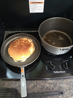
We
both agreed that this trip would be one where we’d not be on any daily time
schedule. This allowed us to have a leisurely first morning with a big pancake
and bacon breakfast. The compact and lightweight cookware set that Alison and
Steph got for us has turned out to be a quite versatile and efficient addition to
our equipment. We spent the balance of the morning and the rest of the day
exploring the campground and the coastline.
The
winter storms did some remodeling of the beach. Much of the area at the eastern
end of the park was strewn with large cobblestones and driftwood. Some of the


The
next day we went on an auto tour of Highway 1 where it splits from the 101
Freeway and heads west toward Lompoc. It goes through some pretty valleys and
farmland on the way to Lompoc. Once you’re in Lompoc, the Santa Ynez River
estuary opens up into large areas of farmland. We took a road that goes to a
place named Surf, which is a dot on the map at the coast where the road ends. When
you get past Lompoc and near the entrance to Vandenberg Airforce base, the road
closely follows the Santa Ynez River and ends at an Amtrak train stop. When we
got there the morning fog was just beginning to lift and we were the only
people there. The tracks run right along the beach and you can see them stretch
out into the distance in both directions with nothing but sand dunes and ice
plants all around. We couldn’t figure out why there was a train stop in such a
remote and desolate location until Karen saw a sign that said you need to call
Amtrak ahead of time in order to schedule a stop at Surf. We think this is an
accommodation to the military personnel out at the airbase. The beautiful beach
was closed, according to posted signs, from March to September by order of the
base commander. An old rusty ammunition
bunker in a sand dune adjacent to the train stop was a reminder that we were in
the middle of a large military installation.


We
headed back toward Lompoc and caught Highway 246 toward Buellton. The road more
or less follows the Santa Ynez River up through the Santa Ynez Valley and into
Solvang. As we passed through Buellton we saw some of the sights/sites made
famous in the movie, Sideways. We stopped in Solvang and took our bikes off the
rack, loaded up a picnic lunch and took an easy tour of the town. We had a
quiet lunch at Hans Christian Anderson City Park, then we cycled over to the
Solvang Brewery for a sampler of the local microbrews.

On
the drive back to camp, we stopped at a vista point along Highway 101 to look
at an abandoned highway bridge at Arroyo Hondo Creek. This bridge must have
been part of the original Highway 1 and it looked like it had been out of use
for many years. A sign placard near the bridge explained that Arroyo Hondo
Creek was one of the best habitats for the endangered California Steelhead
Trout in Santa Barbara County. When Highway 101 was constructed in 1949, this
habitat was virtually destroyed. It wasn’t until 2007 that special fish passage
culverts were constructed to allow resumption of upstream migration for the
fish.
The
following day we packed up to go home. We took a roundabout route along Highway
150 through Ojai and then Highway 126 through Santa Paula, Fillmore and Piru.
This takes you through lots of scenic ranching, farming and agricultural areas.
When you reach I-5, you dive right back into the world famous Southern
California traffic congestion – and you immediately begin thinking about your
next trip out of town.
Next
up: Big Bear, CA in July and (hopefully)
Big Bear, WV in August (Ragnar Trail Race with Steph and Stephan)
No comments:
Post a Comment