CLOSING THE
GAP
Due to some
unexpected technical difficulties, this is a recreated summary of my first
entry on this subject. It turns out that it’s easier to accidently delete blog
entries than it is to enter new ones. I also realized early in our trip that it
was more fun to be on vacation than it was to (1) try to find a cell signal;
(2) review photographs; (3) sit down and start typing at the end of a long day.
For now, I’ll write up some notes in Word and then do editing/pasting later.
Late
December: We had a great trip to Yosemite Valley in the
week between Christmas and New Years. We were there between winter storms, so
there was snow in the valley but we had clear cold weather for our stay. This
made for good hiking conditions on the mostly vertical trails going out of the
valley and up toward Yosemite, Nevada and Vernal Falls. There was ice in many
sections and, thanks to Steph and Stephan, we were introduced to Yak Traks
which are like snow chains for your feet. Next time we’re out in the snow and
ice, we’ll be prepared. Steph and Stephan stayed in the tent cabins at (what
used to be called) Camp Curry and they got to learn all the ins and outs of
bear-proofing their gear each night before bed. NPS videos on bear safety made
it clear that if you left something as innocuous as a tube of lip balm in your
car overnight, a bear would come out of the trees and rip the doors off the car
in order to get inside. Although this may be stretching the point, it was hard
not to think about this each evening. We had a fun dinner, along with Andrew’s
family, one evening at (what used to be called) the Ahwahnee Hotel—it was quite
impressive. On another night, Alison and Andrew learned about NPS hyperbole as
they shivered through a walk that was billed as a ranger-led winter evening
nature hike under the stars, but more closely resembled a frigid elementary
school field trip. While Steph and Stephan drove back to Southern California,
Karen and I took Alison and Andrew on an epic one-day trip from Yosemite to San
Francisco airport, and then (once we dropped them off) on to Sacramento.


We
took the very scenic Highway 120 out of the valley and along the way we stopped
for a 3 mile hike to the Merced Grove of giant Sequoia trees. The hike included
a very snowy and icy trail that featured a mainly downhill profile to get to
the grove and an uphill hike back to the car. It’s hard to appreciate the size
of these trees until you are up close to them. Karen ‘enjoyed’ her vigorous
uphill trek back to the car. After driving for about 12 hours we reached
Sacramento and spent what remained of New Year’s Eve with Dad and Muriel. We
drove back to Fullerton on Jan 2 and met Steph and Stephan before they had to
leave for Virginia. We got in some trail runs and some sushi before they left.
January:
Karen had yet to begin work for the tax season, so we went on a short
mid-week camping trip with our friends, Steve and Paula, to San Clemente State
Beach. It was good to sit around the campfire telling stories, singing songs
and bringing each other up to date. The mornings were cold and clear and I had
the beach to myself on my early morning runs. We managed to dodge the winter storms
for 2 of the 3 nights we were there, but we caught some wind and rain on the
last night. It was a good test for the Aliner and we stayed dry.

February:
Karen was working tax season by this point, so it was up to me to
continue field-testing the Aliner. I went to Bolsa Chica State Beach with Steve
and Paula. There’s nothing like standing on the sand looking at the Pacific
Ocean and then turning around to see the snow-capped San Gabriel Mountains
behind you in the distance. It was cool and breezy at the beach, but you can’t
beat the laid-back feel of winter time at the beach. I got in a good run at the
Bolsa Chica Ecological Preserve across PCH from the campsite and I even found
time to attend an ad hoc ‘board’ meeting one afternoon when I bicycled up to
the Huntington Beach Pier. On the last day there, Windom brought his 1969 VW
Westphalia poptop (the one I used to own) to spend the night and to do some
preliminary planning for our Saline Valley trip later that week. After a quick
trip home to clean up the Aliner and to pack for the next trip, it was off to
Death Valley National Park and the Saline Valley.

Windom and I
had been watching the weather reports and they all called for some major storms
to come through on President’s weekend. Nevertheless, we decided we’d be OK if
we got out to the desert on Thursday so that we’d be in place when/if the
storms came. We took off in the VW before dawn and made it out to Olancha by
mid-morning. The wind was howling out there, but the skies were clear. Coming
in from the south, Saline Valley is close to 60 miles from the nearest paved
road. It took us most of the rest of the day to get out to the campsite. That
afternoon and early evening it was warm and mild and mostly clear. Even the
wind had died down. However, later that evening the wind came up and then the
rain came. It rained pretty steadily all night and all the next day. We brought
the Westphalia camping tent with us – it’s designed to attach directly to the
VW, but it can also be used free-standing. I had purchased the camper back in
1982 from the original owner, who bought it in 1969 in Germany and had it
shipped to the USA after touring Europe for a few months. Although he had the
tent, he did not have the tent poles. When I owned the camper, I made some cheesy,
but functional, poles from PVC. When Windom bought the camper, he upgraded to
electrical conduit poles with several custom fittings and features. While
setting up the tent at Saline Valley, we discovered there was a missing pole.
It was Windom MacGyver to the rescue with some spare conduit and a cutting tool
he keeps in the camper. It was somewhat amazing to see how well the nearly 50
year old tent performed in high winds and driving rain. It stayed up the whole
time and it never leaked. Despite the
weather on Friday and Saturday, we were able to get in some good hikes. The
storms really impacted the ability of other campers to get to the valley. As
campers trickled in on Friday afternoon and Friday night, we heard stories of
deep snow and mud at both the south and north passes.


To no one’s surprise, the
crowds for this usually very crowded weekend, were much smaller than in past
years. This, and the soggy terrain, caused the annual Saline Valley golf
tournament to be cancelled (the golf course consists of five holes, each
delineated by a circle of rocks, spread out over a couple of acres of the
surrounding desert – each player is allowed to use only one golf club, a 7 iron
– it is nearly impossible to find the course because it is indistinguishable
from the rest of the desert – Windom is the defending champion, so he gets to
hold the title for one more year). The weather began to clear late Saturday,
and Sunday was a nice warm day. The mountain ranges surrounding the valley were
covered in snow, particularly the Inyo Mountains. Windom was beginning to worry
about making it out of the valley on Monday – he had another trip planned to
Sedona beginning Wednesday and he would not be held in good favor if he missed
that trip. We had another good hike on Sunday, and then began preparations for
an early departure on Monday morning.

On Monday, the skies in the valley were
clear, but we could see ominous clouds hovering over the southern mountain pass
ahead of us. As we began to climb out of the valley the road quality began to
decline. The storms had caused debris slides and made what was already a
questionable dirt road into more of a challenge. The VW is two-wheel drive, but
with the engine and all our camping gear right over the rear wheels, we had
plenty of traction to get through the mud. At the top of the pass, we hit dense
fog and soggy conditions, but the Windom-mobile made it though. Coming home on
I-15 we got a glimpse of how severe the storm had been when we saw a large
portion of the southbound lanes collapsed at the intersection of Highway 138.

March:
Karen was still working tax season (it was building to a crescendo of
excitement and anticipation at her office), so I took the Aliner out for
another shake-down cruise. Once again, I tagged along with Steve and Paula.
This time we went to Leo Carrillo State Beach. I had never been there and I was
quite impressed with the semi-secluded campsites and the proximity to the
beach. March is a great time to visit, especially after all the recent rains,
with green hills and loads of wildflowers all around. The nights were still
cold and the days a little breezy, but the sun was shining bright. There are
some good running trails in the hills and the beach is also a great place to
get in a morning jog. Located where Mulholland Drive ends at PCH, the vistas at
Leo Carrillo are spectacular, especially if you follow one of the trails into
the hills above the campground. The rock formations at the beach are fun to
climb on and they make good subjects for digital snapshots. The Arroyo Sequit
Creek empties into the beach here and this is only one of three creeks in the
Santa Monica Mountains where there are California Steelhead Trout. One of the
things I discovered on this trip was that my cell phone battery does not last
long when (1) I’m camping without any electrical hookups; and (2) when the cell
reception is so sketchy that the phone is constantly roaming for a signal. Switching to ‘airplane mode’ helps preserve
the battery so you can still use the phone for taking pictures, but you still
need a way to charge the battery at some point. Steve had a portable battery
charger he let me use and I decided I needed to get one of those for future
trips – thanks to Harbor Freight and their handy dandy portable charger, I now
can charge all our hand-held digital devices even when we’re dry camping.


After
the Leo Carrillo trip, there were no more camp outs planned until after Karen
was done working tax season. We made a small modification to the Aliner
cabinetry based on Karen’s idea to add an access door at floor-level on one of
the interior storage cabinets. Our talented neighbor, Mark, did the
installation for us. All that remained was to wait until April 24 – the
departure date for our first extended trip in the Aliner.
April:
Just before our camping trip, we made a short weekend visit to the
Seattle area to be with Dad (who was celebrating his 90th birthday),
Muriel, Jeff, Joanna, Adam, Amy, Finnegan and Forrest. We had fun visiting Adam
and Amy’s new house in Everett and we had fun playing with Finnegan and
Forrest. After a nice birthday dinner at a local Italian restaurant, we headed
back home. On the way to the airport we stopped at the flagship REI store in
downtown Seattle and spent our annual REI dividend check on some last-minute
camping items.
When we got
home, we also had time to make a trip out to Bass Pro Shop to get Karen a
fishing rod and some tackle. She’d been wanting to do some fishing while on our
trip and we found the perfect set up for her:
a lightweight rod and spinning reel.
One of the
most useful things we picked up that day, however, was a set of walkie-talkies.
As I had been learning to back the trailer up into parking spaces and into our
garage during the previous few months, we realized that the combination of
Karen’s voice commands/hand signals and my short attention span/slow response
to commands was not the optimal means to accurate trailer guidance. There were
several times when the neighbors could hear Karen shouting to get my attention
as I weaved in reverse in the general direction of our driveway. The
walkie-talkies provided the opportunity for effective and discreet
communication between the ground crew and the pilot. We tried them out and it
made a big (positive) difference right off the bat. We also figured we could
use the walkie-talkies when we were out hiking and it turned out that this was
another great idea – thank you, Karen.
April
24: Departure day -
Karen was winding down from an intense conclusion to this year’s tax
season, so she was ready to get out of town. We had agreed before the trip to
just take off without any campground reservations – our earlier research had
shown us that you need to have anywhere from 6 months to a one year lead time
to get reservations at the more popular National Park campgrounds. As a result,
everything was already booked up before we even began looking at going on the
trip. One thing we knew was that there were some ‘first-come first-serve’ sites
out there, particularly in the state park system. So, we headed north on I-15
toward Las Vegas. Our plan was to spend the first night at Valley of Fire State
Park in Nevada.
Despite a
somewhat detailed checklist of items, we had a moment of angst when we were out
in the desert somewhere east of Barstow. I asked Karen if she had seen the key
ring with all the trailer keys. I knew I had it in the darkness of the early
morning when we were loading all the gear, but I could not remember what I had
done with it after that. The last clear
memory I had was of setting it on the washing machine in the garage as we
brought things out of the house. Without the keys, we were completely locked
out of the trailer and, in fact, we would not even be able to unhitch the
trailer from the car without cutting off a lock. As a precaution we had brought
an envelope containing trailer manuals and several duplicate keys – we just
weren’t sure which keys, and how many we had. In the meantime, Karen gave me
one of those looks that says, “you’re in big trouble, buster” and suggested
that we immediately pull off the highway and begin a search for the keys. Off
ramps are not too plentiful out there in the desert, but we managed to find one
a few miles up the road. All I could think of was that it would be a long, and
maybe very silent, ride back to Fullerton if we couldn’t find the keys. To my
great relief and surprise, as soon as I got out of the car and stood up, I
could feel the key ring in my front pocket where it had been ever since we left
home. I looked at Karen and said, “see, no problem!” She did not find that as
humorous as I did, but we both relaxed quite a bit knowing that we could keep
our momentum going on the trip.
We
hit Las Vegas at about lunch time. It’s been a few years since I’ve been there
and I was surprised at how far out of town you begin passing huge casino
complexes. Karen said she’d never eaten at a Cracker Barrel Restaurant, so we
found one not far away from a giant Bass Pro Shop near the freeway. The
restaurant was really crowded (where do all the people come from on a Monday
afternoon?) but they got us in quickly and we had a good old fashioned hot
lunch. We got back on the road and drove for what seemed like miles and miles
through Las Vegas.
Valley
of Fire State Park: I-15 heads northeast from there toward the
northern end of Lake Mead. We took the cutoff toward Overton and before long we
entered the Valley of Fire State Park. I had only seen this park as a dot on a
map and then briefly on the state park website. I was pleasantly surprised at
how scenic this area is. I was even more pleased when the park ranger told us
there were plenty of campsites available within the park. We drove in several
miles, found the campsites and set up the Aliner. The campground is nestled among
several red sandstone rock formations and each site has a unique setting. We
spent the afternoon exploring some of the sights in other areas of the park and
even got in a short hike to Mouse’s Tank, which was reportedly a bandit hide
out back in the day. The ‘tank’ is a dry waterfall pool and is part of a larger
waterfall/streambed that probably has imposing amounts of water during flash
flood events, but is otherwise dry. The trails around here are very sandy and
the sand is a distinctive red color. At this time of the year there were lots
of wildflowers in bloom among the rocky outcrops. We saw some petroglyphs along
the trail, but Karen thinks (and I agree) they may have been done much more
recently than ancient times even though they’re in the style of the old
petroglyphs. On the way back to camp we saw a mountain goat posing for us at
the side of the road.


Everything
worked good in the Aliner the first night. As we were cleaning up the campsite
the following morning we both heard what sounded like a large explosion in the
campground. We looked up the side of a large rock outcropping on the opposite
side of the campground and saw a huge plume of dust and debris as the sound of
the explosion continued to reverberate through the area. After a few moments,
we realized we were seeing a large rock slide in progress. This slide occurred
on the upper section of the rocks, so it did not reach the campsites directly
below it. It was amazing to see how suddenly and how powerfully something like
this can happen. It sounded like a bomb went off. Fortunately, no one was hurt
and there was no damage to anyone’s property. About an hour later, a park
ranger came by and asked us questions about what we’d seen and heard. He wanted
to get a report into his supervisors so they could investigate further when
they had the chance. He told us he’d not heard of this happening in the
campsite areas previously, although with all the rain we had this year he was
not surprised there was some instability up in the rocks. Shortly after this,
we packed up and headed for Zion. On the way out of the park we stopped to look
at some real petroglyphs high up on a rock that was accessed by a staircase
installed by the park service.
Zion
National Park: I-15 continues northeast along the Virgin
River and through the scenic Virgin River Gorge as you begin your climb to the
Colorado Plateau. This was the first test of the Subaru’s towing power as we
wound our way up the road. Everything was working well as we headed toward the
turnoff to Hurricane, La Verkin and Springdale. We got to the park entrance at
about mid-day and promptly got confirmation that if we wanted to camp within
the park boundaries we’d have to do our planning many months to a year in
advance – there were no sites available. The ranger handed us a referral sheet,
however, and we quickly found an RV park about a quarter mile south of the park
entrance that had availability. We checked in and got three nights confirmed.
They set us up with a full hook-up site right on the Virgin River.
The rest of
that day we took a sightseeing drive along Highway 9 through the tunnel and
toward the eastern entrance to the park. We went as far as Checkerboard Mesa
and turned around. The tunnel is quite a sight to see and if you have a large
RV they make you pay a fee to go through it – they also halt traffic and
convert the road to one direction only when a large vehicle is going through.
The road itself provides lots of striking panoramas and vistas of Zion Canyon.
The second morning we got up early and caught the 7:30am shuttle into the
Canyon. I have to say it’s a little disconcerting to have to plan your
activities around expected crowds, and it took something away from the overall
experience for me. Nevertheless, we did a full day of hiking along the Emerald
Pools trail (we saw some mule deer grazing on the slopes above the upper pool
and we passed a long unbroken line of senior hikers coming up the trail on a
guided tour), the Kayenta Trail (and a nice picnic lunch at the Grotto) and the
Sand Bench Trail (this last trail is also a horse trail and had more sandy soil
than we want to have on a hike – but it ended at the Court of the Patriarchs
which has a great view and a shuttle stop).
Karen got on the shuttle and I continued hiking along the pedestrian/bike
trail back to the Visitor Center where we met up again and went back to camp.
It was a good day, but it seemed like the park was awfully crowded for this
time of year.
The
next day we took an auto tour of the Upper Kolob Plateau via Kolob Terrace
Road. On the way out of Springdale we stopped at one of the art galleries in
town and saw many pieces of Windom’s ceramic art that are on display there –
they look good! Kolob Terrace Road climbs quickly up to 8000 feet elevation
where the road ends at Kolob Reservoir. It was cold up there and we found
plenty of snow still laying on the ground. Lava Point Overlook is along the way
and gives a great view out toward the eastern part of the park. This part of
the park is very lightly travelled and gave us a break from the traffic and
crowds of the canyon. While we were at it, we went up to the far northwest
entrance of the park and drove along Kolob Canyons Road. There are lots of
great views along this road and many hiking trailheads start from there. Next
time we’re there, I’d like to hike the La Verkin Creek trail out to the
Kolob Arch – other campers told us it’s
well worth the hike to get out there. On our third night we met with Laurie
(Karen’s work colleague) and her husband, David. They were returning to
California from a family visit to New Mexico and happened to be passing through
Springdale at the same time we were there.
The
next morning we took off for Escalante. Karen had done some searching for
campsites in the general area of Bryce Canyon and found availability at
Escalante Petrified Forest State Park. We took Highway 9 out of Zion via the
tunnel to the east entrance of the park. There, we hit Highway 89, which
follows the east fork of the Virgin River north toward Bryce Canyon. When we
stopped for gas at a two-pump station in Orderville, we were told by one of the
locals that the highway up ahead would likely be closed temporarily. He said a
truck full of watermelons had overturned and blocked the lanes. We headed north
anyway and found the road clear. All that remained at the accident scene was a
big pile of watermelons, some smashed and some still intact. A couple of
motorists had stopped to sift through the rubble and stock up on some free
watermelons. As we continued toward Escalante, we took the very scenic Highway
12, where we hit some pretty cold weather. In fact, when we got up to Bryce
Canyon it was snowing and the temperature was in the 30’s. From this point
forward and for the remainder of the trip we were always at or above 6000 feet
elevation.
Escalante
Petrified Forest
turned out to be one of the highlights for us. The campground was small and
very well maintained. Our campsite sat up on a hill with a nice view of the
Wide Hollow Reservoir in front of us and red sandstone rock formations just
behind us. A short hike into the hills led to some of the best petrified logs
I’ve seen. One section of the hike (Sleeping Rainbow Loop) featured petrified
logs nearly every step for almost a quarter mile. Quite a treat if you’re into
that sort of thing.

After
our first night in Escalante, we took a day trip to Capitol Reef National Park.
Highway 12 becomes very scenic as it winds its way up and over the Grand
Staircase plateau and over a mountain range with a 9600’ summit. The so-called
‘million dollar highway’ between Escalante and Boulder is an amazing
engineering feat and quite a ride in the car. This includes the ‘hogsback’
section, which rides along a high ridge with steep drop offs on either side of
the road – there’s nowhere to pull over without sliding over the side. (side
note: a storekeeper in Escalante told us there is an annual marathon, the
Escalante Marathon, every October that goes from Boulder to Escalante. I
believe it follows this same general route) We ran into snow and wind again at
the summit of one of the passes, and then we dropped down to Capitol Reef.
This
is a low key national park with no formal entry station. We found a one mile
dirt road to a trailhead for the Cassidy Arch hiking trail. The printed park guide
called this a ‘strenuous’ hike and they weren’t kidding. We were still
acclimating to the high altitude, and the steep switch-backs were a constant
reminder of our conditioning. This was our first real opportunity to test our
new hiking poles. Karen did great on this trail, which featured some pretty
gnarly sections with steep drop offs and questionable footing. We also tested
out our new walkie-talkie set on this hike. If I got ahead of Karen on the
trail, we could still stay in contact. Karen let me take off to view the
Cassidy Arch, which is accessed by scrambling over large sections of slick
rock. I took off up the trail with a vigorous pace – so vigorous that I passed
the turn off to the arch and continued onto the Frying Pan Trail and on up to
the ridge top above the arch. When I’d realized my mistake, I’d already added
nearly 2 miles to the hike. I turned around and made radio contact with Karen,
who suggested we should head back to the car since it was getting to be late in
the afternoon. Duly chastened by my sub par navigation skills, I hiked back down
to meet Karen without having seen the arch up close. Regardless, we had a great
hike and we saw some unbelievable vistas from the trail. We had a late lunch at
the car and then returned to Escalante that evening.
The
next day, we declared a holiday from travel and we stayed at the campground
while Karen perfected her skills with her new fishing rod and reel at the reservoir.
Neither of us knew what we were doing, but Karen eventually got real (reel?)
good at casting and at retying hooks and leaders. We tried several different
spots at the reservoir, but never caught any fish. I’m sure the next fishing
trip will go smoother than this one – we learned a lot about what works and
what doesn’t.

We went into the town of Escalante that evening to get supplies
for dinner. We found out that the main grocery store was closed on Sundays. The
only other food store in town was an upscale natural/organic food store that
did not specialize in supplying frugal campers. After much searching and
deliberation, we ended up buying a four-pack of designer sausages for nearly
ten dollars. To soften the economic blow, we managed to make two night’s worth
of meals from them. The following day was going to be a travel day to
Kodachrome Basin State Park.
Kodachrome Basin State Park is a relatively
short drive back down Highway 12, so we had some time to do a little more
fishing at the reservoir before we hit the road. The fish weren’t biting in the
morning, either. As we were packing up, we met Jim and Jackie, a retired couple
from Colorado who were also camping. They had just paddled in to the shore on
some really cool inflatable kayaks. We spent time talking about the kayaks (a
great idea for future outings, since they weigh about 35lbs each and fold up
into small carrying cases) and learned that they were also headed to Kodachrome
the next night. We agreed to find them and share some more stories around the
campfire. Then we took off.
Kodachrome Basin State Park
was another very pleasant surprise. The campsites were semi-secluded and the
surrounding scenery was spectacular. Our Aliner was parked near a towering
sandstone ‘pipe’, one of many that are the hallmark of this park. After setting
up camp, we took an 11 mile (each way) dirt road trip out to see Grosvenor
Arch. The arch was named after Gilbert Grosvenor, one of the early movers and
shakers in the National Geographic Society. While out there we met a young
woman from New Jersey who was spending two to three months hiking in the
wilderness on the Hayduke Trail, a strenuous 800 mile hike through the
backcountry of the Colorado Plateau. She told us that in preparation for the
hike, she and her hiking partner had spent a week placing several caches of
food and supplies at strategic spots along the route – quite an undertaking.


While
at Kodachrome, we hiked the several trails in the park. We also met up with Jim
and Jackie, who we’d met back at Escalante. We spent an enjoyable evening
around the campfire swapping stories and singing songs. We also had an
impromptu gathering of pop up trailer enthusiasts. Throughout our trip, we had
several people stop by and ask about the Aliner and we always obliged by giving
a short (can it be anything else in a 12’ space?) tour and sharing of camping
experiences. At Kodachrome, the gathering was larger and more lively than
before as several people dropped by at the same time to ask about the Aliner.
This led to lots of stories, suggestions and recommendations by all involved.
It was great getting to talk to so many people from so many different
backgrounds.
On
our last morning at Kodachrome, we took a horseback ride on the Panorama Trail
loop, which we had hiked the previous day. Our wrangler was a real-life cowboy
named, Steve. Just as you’d expect, he
was a man of few words and he was an excellent horseman. Once we got out on the
trail, he opened up a bit and told us stories about Butch Cassidy, who
apparently was born and raised in nearby Circleville, UT to a Mormon family
(when we later drove up Highway 89 through Circleville, we saw a sign
proclaiming the town as the birthplace of Butch Cassidy). Karen and I were the
only riders that morning – in fact, we were the first riders in nearly a week,
according to Steve. With just the three of us riding along the trail, it was
easy to imagine what it must have been like back in the old days, when cowboys
and desperados rode over the same land. It inspired me so much, that I pulled
out my guitar at the end of the ride and sang the old Sons of the Pioneers
standard, ‘Cool Water’ – I think the horses in the corral enjoyed that.
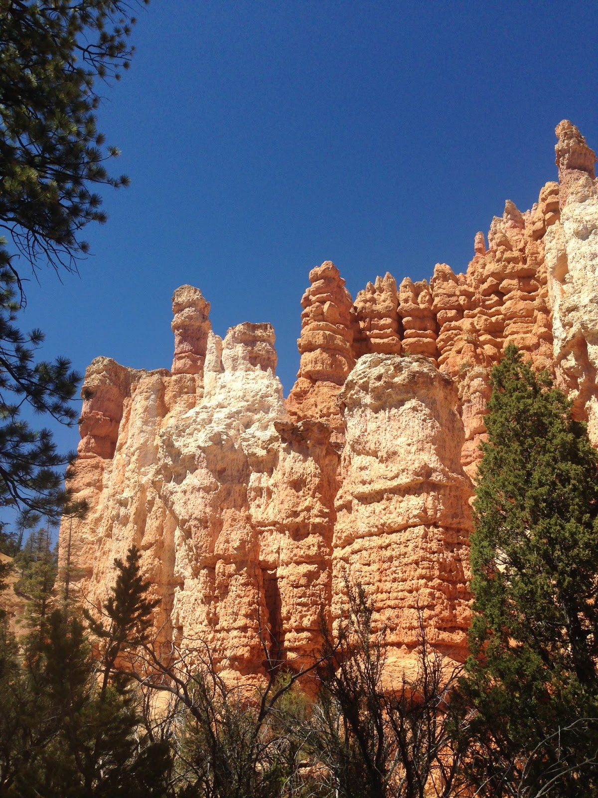
Bryce
Canyon National Park: After shaking off the trail dust, we took the
short drive from Kodachrome Basin to the Bryce Canyon RV park, where we had
reserved two nights. Located on Highway 12 about 3 miles from the entrance to
the national park, it was a good location to use as a base. It also had
electricity and cellular reception – something we had not had much of for the
previous couple of weeks. Our first afternoon, we took an auto tour through the
park out to the end of the road at Bryce Point. We hit all the viewpoints on
the way back and got a good idea of which trails we’d hike the following day.
Bryce had a much lower-key vibe than Zion, which I suppose was a combination of
the cooler weather, higher altitude and its distance from Las Vegas Airport.
There was still snow in many of the shadier sections of the park.
The
next morning, we started out by taking the Queen’s Garden hike down into the
canyon. It’s categorized as one of the easier hikes, but it’s no walk in the
park. It quickly drops down into the canyon via a series of switchbacks. When
you turn around and look back up the trail, you can see what’s in store on your
return trip. But the view inside the canyon makes it all worthwhile. It’s an
other-worldly experience, fueled by a combination of the striking views and a
lack of oxygen. Karen was having some leg stiffness that morning, but she did a
great job setting a consistent pace as she climbed back out of the canyon. Once
at the top again, we had some lunch and Karen returned to camp while I set out
on the 8 mile Fairyland Loop Trail. We agreed I’d do this hike, take the
shuttle back down to Bryce Canyon City and call Karen for a ride back to camp.
The
Fairyland Loop trail is a steep trail that drops into the canyon, then rises up
and down among and atop various ridges within the canyon. It’s a much less
crowded trail, and for most of the hike I saw no one else at all on the trail. It’s
pretty hard to find enough words to describe the landscape down in the canyon,
so I just took a lot of pictures and channeled my inner-Huell Howser with my
GoPro. Once I completed the hike, I found Karen at an ice cream shop in Bryce
City and we headed back to camp.


We decided to eat at a local steak house for
dinner that night as a reward for our day of hiking. The restaurant had that
authentic roadside ambience and our waitress was a champion barrel rider (she
was sporting the huge belt buckle to prove it) who told us all the beef was
locally grown. Karen was not impressed with her filet mignon, which more
closely resembled a skirt steak than the tender cut that we city-slickers are
used to. We were told that the local butcher prepared the filets that way to
enhance the flavor. Karen was not amused. My prime rib, however, was very
tasty. The homemade multi-berry pie for desert helped make up for the
frontier-cut filet and we were both ready to hit the road the next day.
Back in
camp that night, I ran into a fellow camper who had also just recently retired.
He retired (or, was trying to retire) from a career as a jazz guitarist in the
Boise, ID area. Since I had both my guitar and a ukulele with me, I asked if he
wanted to play some tunes. We went to his trailer (Karen decided to stay in the
Aliner and read) and had a little jam session. He was an excellent jazz
guitarist and he could play any style of guitar. It was fun playing along with
someone who I found it hard to keep up with. As often happens in these
situations, time passed quickly and I got a call on my telephone from Karen
(next door) at a little before 11:00PM recommending I call it a night. I was
surprised I was even awake at that hour, so we ended the jam. This was just
another example of the interesting people we met along the way.
The
Loneliest Highway: Karen and I had decided to return home via a different
route than the one that brought us here. We pulled out the map and set a route
that would allow us to spend a couple of days with Dad and Muriel in
Sacramento. Our plan was to do this and then work our way back from Sacramento
via Pinnacles National Park or Avila Beach (more on this later). The most
interesting route to Sacramento appeared to be via U.S. Highway 50 – the so-called
‘loneliest highway’. So, we set out for our first night’s stay in Ely, NV. To
get to Ely, we took Highway 89 north to Salina, UT. This is a very picturesque
stretch of highway that follows the Sevier River through canyons and sweeping
valleys and ranch land. At Salina, we hit Highway 50 and began our trip over and
through the Basin and Range country. This is a two-lane highway that goes up
through several mountain passes and drops down into huge basins/valleys. At
this time of year, all the ranges were snow-capped and the valleys were
characterized by large dry lakes and scattered wildflowers. It was obvious we’d
had a wet winter because there were several areas where we could still see some
standing water. Otherwise, this is desolate terrain – you certainly don’t want
your car to break down out here.
We
made Ely in the early evening and had time to make it to a Mexican restaurant
located within a local casino. It was Cinco De Mayo, so we each had a large
margarita. After dinner, Karen hit the Sherlock Holmes Adventure slot machine
and managed to contribute more money to the Nevada gaming industry. Outside,
the wind was blowing hard and it looked like we were in for a change in
weather.
The
next morning we headed for our next stop, Fallon, NV. In order to get there we
had to traverse several mountain passes along Highway 50. Just before we got to
Fallon, we took a side trip to Great Basin National Park (I didn’t even realize
Nevada had a national park) for a quick tour.
Great Basin National Park: Like everything else in this part
of the country, the roads take you up to high elevations very quickly. We took
a steep drive up to the Lehman Caves to see if we could get in on a tour.
Unfortunately, the next tour was starting later than we wanted to stay, so we
decided to take a drive within the park to check out the campsites. To do this,
we took an even steeper road that got us up to nearly 9000 feet elevation in a
very short distance. We were pulling the Aliner, so this was a real workout for
the Subaru. The campsites here are quite scenic and this looks like a good
place to camp if we ever pass through this way again. I decided to try out my ‘hill
descent’ feature on the Subaru to see how that would work going back down the
very steep grade. As it turns out, this is really not a feature made for using
while pulling a trailer. All it did was overheat my brakes. Once I switched
back to using the trailer brakes along with the car brakes, everything went
well. We made it to Fallon in the early afternoon and restocked our supplies at
one of the largest Wal Marts I’ve ever seen.

By the time we got set up at the
Fallon RV camp (right on the highway and a little long in the tooth – we don’t
recommend this one) the wind was picking up and big thunder clouds were forming
on the horizon. I managed to get some hamburgers on and off the BBQ just before
the rains came. We spent a pleasant evening in the Aliner watching it rain and
playing a rousing game of UNO. It was windy and rainy all night long, but the
Aliner passed the rain and wind test and we stayed warm and dry.
Next morning
it was off to Sacramento. Highway
50 climbs quickly and steeply out of Carson City and before long we were up in
the snowy Sierras. The rain that hit us in Fallon during the night was falling
as snow up in the mountains. It looked like we had stepped back 3 months and we
were in the dead of winter. Lake Tahoe was grey under low clouds and a stiff
breeze. We got out of the car a few times for some snapshots and then continued
west. It’s been a long time since I was in South Lake Tahoe and I was a little
surprised at how much it has grown and by how congested the area has become.
The drive down the western side was very scenic as the highway followed the
south fork of the American River. The river was flowing strong with the early
spring snow runoff. Wildflowers were everywhere along the roadside. We made it
down to the junction of Highway 50 and Business 80 and we knew we were back in
civilization.
We
had a great visit with Dad and Muriel and we got to join in one of their
regular Wednesday night dinners with Jeff, Joanna, Don, Brenda and Terry. While
there, Karen got a call from our cat-sitter, who told Karen that our cat had
bitten her. True to form for this animal, the cat had lain in wait for the
cat-sitter and struck suddenly and stealthily. Karen decided that we should
return directly home from Sacramento rather than take a couple of days camping
along the way. This means we’ll have to try Pinnacles and Avila Beach another
time. We left for home on Thursday and had an uneventful ride home, except for
the large snake we came upon in one of the rest areas along Highway 99. We knew
we were back in the city when, after driving for 7 hours from Sacramento to
Pasadena, it took us another 2 hours to get from Pasadena to home. After nearly
2500 miles, the last 40 miles were the toughest.
We’ve already booked our next
getaway – we’ll be hitting El Capitan State Beach for a few days at the end of
May.